3D Geological Modelling Software Features
GEOREKA combines volumetric domain modelling, integrated machine learning, and visual workflows in a single, affordable package. Every feature listed here is included in the base license — no extensions, no add-ons, no surprises.
CORE CAPABILITIES
What Sets GEOREKA Apart
Six capabilities that fundamentally change how you build, validate, and communicate geological models.
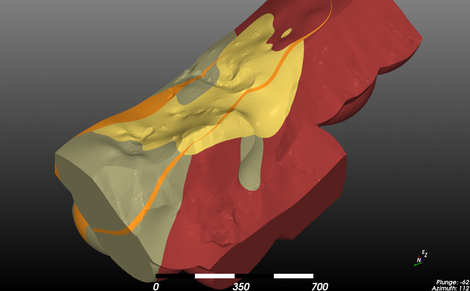
Volumetric Domain Modelling
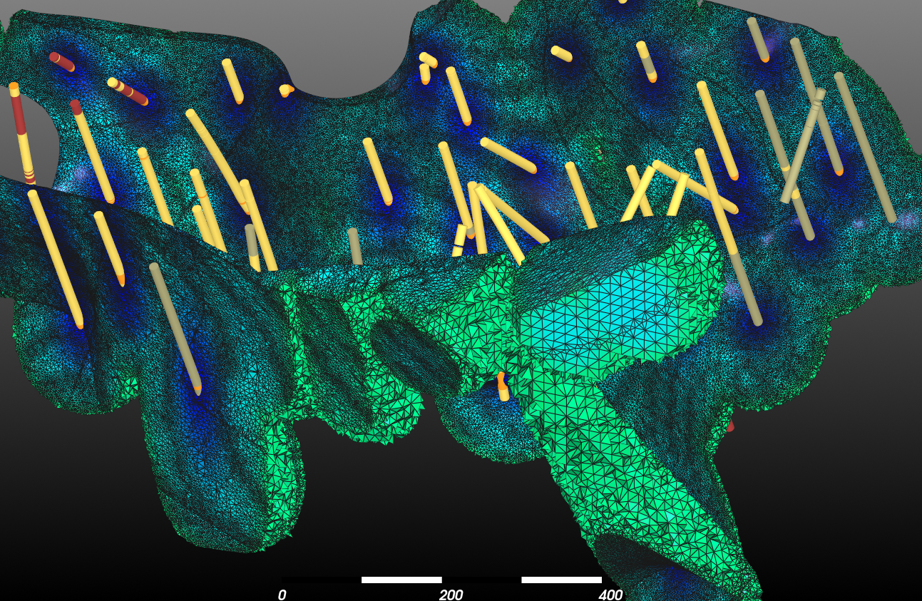
Every geological domain is a true 3D volume from the start — not a set of boundary surfaces stitched together. Define domains using inside/outside points and implicit functions. Output as tetrahedral grids, triangulated solids, or block models.
Resource Estimation
Compare Inverse Distance Weighting, Radial Basis Functions, Ordinary Kriging, and ML regression in a single view — all included in base price. Evaluate on regular grids or directly on your geological model. Volume and grade summaries update in the information panel.
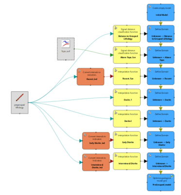
Visual Node-Based Workflows
Every modelling step is visible in an editable workflow graph. Trace any result back to its input data. Reuse workflows across projects. A single image documents your entire modelling process — from raw drillhole data to final model.
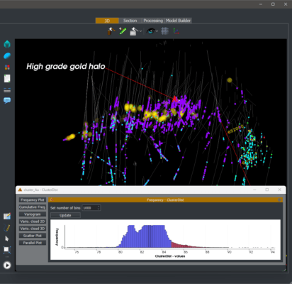
Multi-element analysis
Dynamically link 2D scatter plots to the 3D view — select a cluster in the plot and see it light up spatially. Explore inter-element relationships using ML feature similarity clustering. Identify geochemical halos and sub-domains across all elements simultaneously.
Narrow Veins / Dikes
Model complex veins and dikes with the implicit Vein object. Hanging wall and footwall points are classified automatically from manual selections, one vein at a time. Combine vein and dike models in the domain modelling process to create vein systems and dike swarms.
Structural data
Estimate structural orientation from grade data to validate if grades are correlated to structure. Highlight main structural trends from structural surfaces interpolated directly from structural measurements.
Core Innovation
Domains as Volumes, Not Boundaries
Most geological modelling software forces you to define domains by digitizing contact surfaces. GEOREKA takes a fundamentally different approach: every domain is a 3D volume described by a signed distance function (SDF).
Provide inside and outside points — from drillhole intervals or manual picks — and GEOREKA estimates an implicit function that describes the entire volume. Combine multiple domain functions to define their relative ages and relationships: intrusions, unconformities, faults, and stratigraphic sequences.
- Only mining software producing native tetrahedral grids
- Watertight models with exact domain boundaries
- No sub-blocking needed — tetrahedra conform to boundaries precisely
- Direct export for geotechnical, geophysics, and flow simulation
- Switch between tetrahedral, solid, and block model output with one setting
Transparency
Visual, Reusable Workflows
In GEOREKA, modelling is not a fixed pipeline from input to output. Instead, you build a workflow that fits the problem at hand — and every step is visible in an editable node graph.
Each workflow documents exactly which data sources, interpolation methods, and domain definitions were used. Share a single screenshot with a reviewer and they can understand your entire methodology. Workflows are saved with the project and can be reused across new datasets with different drillhole data.
- Every processing step is visible — no hidden parameters
- Clone and adapt workflows for new projects in minutes
- Built-in documentation: workflows are their own methodology report
Data Analysis
Multi-Element Analysis and Clustering
Traditional geological analysis looks at elements one at a time. GEOREKA’s clustering tool analyses all elements simultaneously in a higher-dimensional space — combining X, Y, Z coordinates with Au, Cu, As, Mo, Pb, Zn, and any other assay values.
Automatically clusters elements based on high, middle and low grade, before GEOREKA calculates a similarity measure for every other sample in the dataset. The results, mapped back to 3D, can reveal geochemical halos, sub-domain boundaries, and multi-element correlations that single-element analysis would miss.
- Analyse unlimited elements simultaneously — not one at a time
- Interactive linking between scatter plots and 3D spatial view
- Identify geochemical halos invisible to single-element methods
- Works with continuous numeric data — no categorical bias
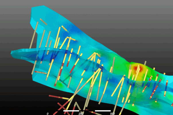
Resource Estimation
Multiple Estimation Methods in One View
GEOREKA treats every interpolation method — Inverse Distance Weighting, Radial Basis Functions, Ordinary Kriging, and ML regression — as a function that can be evaluated, compared, and combined.
View two estimation results simultaneously in the 3D window with real-time cut-off adjustments. Evaluate functions on regular grids or directly on a geological model to get volume-weighted grade averages. The information panel displays tonnage, grade, and volume for any cut-off — no separate reporting step needed.
- All key estimation methods included — not a paid extension
- Real-time cut-off adjustment with instant volume/grade update
- Evaluate on grids, geological models, or tetrahedral meshes
- Side-by-side visual comparison of any two methods
COMPLETE REFERENCE
All Features at a Glance
Data Management
- Import drillhole data (collar, survey, assay, lithology)
- CSV and all standard formats supported, e.g. DXF, msh and Lidar
- Drillhole desurveying (minimum curvature)
- Drillhole data error checking
- Manual polyline digitizing
- Topography surface import
- Multiple data sets per project
- Compositing and sample management
Geological Modelling
- Implicit modelling with Machine Learning, Kriging or RBFs
- Traditional explicit modelling (contacts, surfaces)
- Domain relationship system (Model Descriptor)
- Fault modelling and fault domain interactions
- Stratigraphic sequence modelling
- Intrusion and unconformity modelling
- Tetrahedral mesh generation with optimisation
- Block model generation
- Triangulated solid output
- Watertight model construction
Estimation & Analysis
- Inverse Distance Weighting (IDW)
- Radial Basis Function (RBF) interpolation
- Ordinary (Dual) Kriging
- Machine learning regression
- Multi-element similarity clustering
- Dynamic 2D/3D plot linking
- Interactive cut-off analysis
- Volume and grade reporting
- Method comparison tools
Visualisation
- Real-time preview of implicit functions
- Dynamic cross-sections through any plane
- Adjustable transparency and cut-offs
- Drillhole display with interval colouring
- Surface rendering (triangulated, implicit)
- Grade shell visualisation
- High-resolution export for reports
Workflows & Productivity
- Visual node-based workflow editor
- Reusable workflow templates
- Complete audit trail for every model
- Project file management
- Selective updating of models through user-controlled workflow reuse
Licensing & Collaboration
- Annual floating license ($6,500/yr)
- Transferable between team members
- Free standalone geology viewer
- Academic licenses available
- 14-day full-functionality free trial
- No activation fees
- No feature-gated extensions
Ready to model geology your way?
Join geologists worldwide who switched to GEOREKA for better modelling, clearer workflows, and fair pricing. Your 14-day trial includes every feature — no limitations.