
Resource classification software
Premium
GEOREKA is resource classification software that helps geologists assign Measured, Indicated and Inferred categories to a 3D resource model by drill spacing or by Nyquist–Shannon sampling adequacy, and report grade and tonnage by domain and cut-off, while the Competent or Qualified Person remains responsible for the classification.
Resource classification expresses confidence in an estimate under reporting codes such as JORC, NI 43-101, SAMREC and PERC. No software certifies a resource: the code applies to the public report and to the named person who signs it. What GEOREKA provides is the technical groundwork: validated estimates, classification support in the model, grade-tonnage tables, and an audit trail from raw drillholes to final numbers, so the work can be reviewed and defended. Classification can follow conventional drill spacing and hole counts, or a Nyquist–Shannon sampling-adequacy method that judges the spacing against how continuous the grade is in each domain. Classification and reporting are part of Premium.
What it does and does not do
What GEOREKA does and does not certify
What GEOREKA does
- Supports assigning Measured, Indicated and Inferred categories to model volumes by distance and hole count, by simulation precision, or by Nyquist–Shannon sampling adequacy
- Records the unresolved variance (ε) and a prediction-error floor for every block, so you can see how well the spacing resolves the grade
- Reports tonnage and grade by domain and cut-off, with classification support
- Provides validation evidence: swath plots, cross-validation and side-by-side method comparison
- Records the whole method as a visible, editable workflow, an audit trail from raw data to final numbers
- Exports tables and images for inclusion in a report
What GEOREKA does not do
- Certify a resource or declare compliance with any reporting code
- Replace the judgement and sign-off of the Competent Person or Qualified Person
- Replace the disclosure and technical reporting a code requires, such as a JORC Table 1 or an NI 43-101 technical report
The reporting workflow
From validated estimate to report tables
- ValidateCheck the estimate with swath plots, cross-validation and side-by-side methods.
- ClassifyAssign Measured, Indicated and Inferred categories to model volumes.
- ReportGrade-tonnage by domain and cut-off, with classification support.
- DocumentThe node-based workflow records the method from raw drillholes to final model.
EVIDENCEPremium
Evidence that stands up to review
A reviewer wants to see how you got to the numbers. GEOREKA keeps every step visible: a node-based workflow from raw drillholes to final model, with no hidden parameters. One screenshot documents the entire method.
- Swath plots and cross-validation
- Conditional simulation for uncertainty
- Complete audit trail for every model
CLASSIFICATIONPremium
Classification support in the model
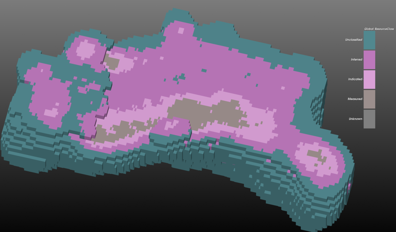
Assign Measured, Indicated and Inferred categories to the resource model and see them in 3D, in context with the drillholes that support them. GEOREKA classifies each block by its distance to the nearest drilling, measured in a plain sphere, a global ellipsoid or the local direction of continuity (LVA), together with a minimum number of drillholes inside each distance ring. You set the distances and counts. Two further methods are available: classification by conditional-simulation precision, and the Nyquist–Shannon sampling-adequacy method below. The category assigned remains the Competent or Qualified Person’s decision.
REPORTINGPremium
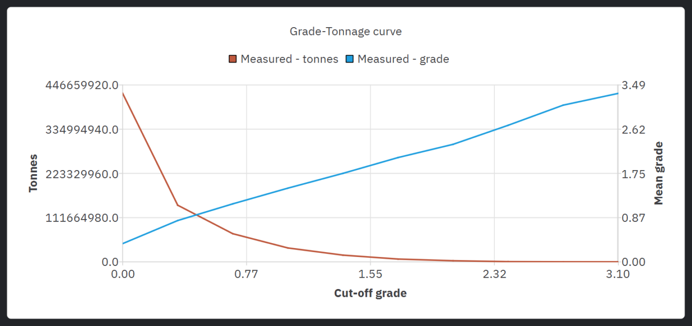
Grade and tonnage by domain and cut-off
Report tonnage and grade for each domain at any cut-off, with classification support, from the same model you estimated on. No export to a second package.
EXCLUSIVE – SAMPLING ADEQUACYPremium
Is the grade structure sampled densely enough?
To our knowledge, GEOREKA is the first mining geology software to classify resources with the Nyquist–Shannon sampling theorem, a method drawn from research published in 2026 (Lu and Wang, 2026, Mathematical Geosciences).
Classification by drill spacing asks how far a block is from the nearest holes and how many holes inform it. The Nyquist–Shannon method adds a second question: given how continuous the grade is in this domain, is the spacing fine enough to resolve its structure at all?
The continuity range and kernel of the interpolation function used for each domain set the finest spatial detail the data must capture. Where the sample spacing is coarser than that, the detail is aliased: a share of the spatial variance cannot be recovered by any estimator, however good. GEOREKA works out that unresolved share, ε, for every block and classifies by tolerances on it.
- Spacing is judged against continuity: the same drill grid can be adequate in a long-range domain and inadequate in a short-range one
- Direction-aware: with a structural data set, under-drilling across strike counts against a block even when the spacing along strike is fine
- Per-block outputs: the class, ε and a prediction-error floor, stored as attributes you can colour, filter and report on
- Thresholds are yours to set: absolute tolerances on ε (1%, 5% and 10% by default) or relative thresholds within each domain
- Runs as a step in the node-based workflow, so the settings are saved and reproducible
Like any method built on a fitted range, it is only as reliable as that range: sparse data tends to overstate continuity, which can flatter the result. Use it beside distance-and-count or simulation-precision classification, not instead of them. Where the methods disagree is where the classification deserves a closer look.
How they differ
Distance and hole count versus Nyquist–Shannon
| Distance and hole count | Nyquist–Shannon sampling adequacy | |
|---|---|---|
| Question it answers | How close is the block to drilling, and how many holes inform it? | Is the grade structure here sampled densely enough to be resolved at all? |
| What is measured | Distance to the nearest samples (plain sphere, global ellipsoid or local LVA direction) and the number of distinct holes in range | Effective sample spacing relative to the continuity range of the domain’s own interpolation function, in the local direction of continuity |
| Same spacing, different geology | Same class for the same distance: one set of distances applies across the model | Different class: short-range domains need tighter spacing than long-range domains |
| Thresholds | Distances and minimum hole counts that you choose | Tolerances on the unresolved variance ε that you choose, or relative thresholds within each domain |
| Output per block | Class | Class, unresolved variance ε and a prediction-error floor |
GEOREKA provides both as well as a third method, based on conditional simulation. It measures how precise the estimate is at the current spacing. It answers a different question again: how precise the estimate is, rather than whether the spacing resolves the geology. Choose the method you want or compare all three side by side.
Reporting codes
Four codes, one set of categories
| Code | Jurisdiction | Signed off by |
|---|---|---|
| JORC | Australasia | Competent Person |
| NI 43-101 | Canada, with CIM Definition Standards for classification | Qualified Person |
| SAMREC | South Africa | Competent Person |
| PERC | Pan-European | Competent Person |
The categories
Measured, Indicated and Inferred
Inferred
The lowest confidence category. Evidence is limited, and geological and grade continuity are implied rather than verified.
Indicated
A reasonable level of confidence. There is enough data to reasonably assume continuity of geology and grade.
Measured
The highest confidence category. Closely spaced data confirm continuity of geology and grade.
The three categories are common to all four codes. Each code sets its own criteria, and the Competent or Qualified Person applies them.
For consultants and reviewers
Hand over the method, not just the numbers
Consultants can share the 3D model with a client or peer reviewer through the free GEOREKA Viewer, and hand over the workflow as a record of how the model was built. See how GEOREKA fits consulting work.
Related
Continue through the workflow
Resource estimation
Statistics, variography, kriging, validation and grade-tonnage results on the same model.
Geological modelling
Implicit and explicit workflows, true 3D domains, structural modelling and fast model updates.
Questions
Frequently asked questions
Is GEOREKA JORC or NI 43-101 compliant?
Reporting codes apply to public reports and to the Competent Person or Qualified Person who signs them, not to software. GEOREKA supports the technical work behind a compliant report: validated estimates, classification support, grade-tonnage tables and a complete audit trail. The person responsible for the report remains responsible for compliance.
Does GEOREKA classify resources automatically?
Classification is a professional judgement. GEOREKA supports it with distance-and-hole-count classification, simulation-precision classification and Nyquist–Shannon sampling-adequacy classification, and the Competent or Qualified Person decides the categories applied.
What is Nyquist–Shannon classification?
It is a classification method that tests whether the drill spacing is fine enough to resolve the grade structure of each domain, using the Nyquist–Shannon sampling theorem and the continuity range of the interpolation function. GEOREKA works out the share of spatial variance that the spacing cannot resolve (ε) for every block and classifies by tolerances on it. The method follows Lu and Wang (2026), published in Mathematical Geosciences.
How is it different from classifying by drill spacing?
Classification by drill spacing uses distances and hole counts, with one set of distances for the whole model. The Nyquist–Shannon method judges the spacing against the continuity of each domain, so the same drill grid can be adequate in one domain and inadequate in another. With a structural data set it also follows the local direction of continuity, so under-drilling across strike counts against a block. It also records ε and a prediction-error floor for every block.
Does it replace distance-based classification?
No. Both are available and answer different questions, alongside the simulation-precision method. Give each run its own output name to compare them side by side, because a run that reuses an existing output name overwrites the earlier result.
What do I need to run the Nyquist–Shannon method?
A block model, the composites, and at least one domain mapped to the interpolation function used for it. GEOREKA reads the kernel type and continuity range from that function, and you can override the range. A structural data set is recommended, and without one the method falls back to a global anisotropy ellipsoid.
Which licence tier includes classification and reporting?
Classification support and grade-tonnage reporting are part of Premium, together with the rest of the full resource estimation suite. The 14-day free trial includes every Premium feature. See pricing.
Can I show my method to an auditor or peer reviewer?
Yes. Every model is built as a visible, node-based workflow, so any result traces back to its input data and one screenshot documents the method. A reviewer can also open the 3D model in the free GEOREKA Viewer.
Which reporting codes does this support?
The Measured, Indicated and Inferred categories and grade-tonnage tables are common to JORC, NI 43-101, SAMREC and PERC. Each code sets its own criteria for applying them, and the Competent or Qualified Person applies those criteria.
Get started
Take an estimate through to grade-tonnage reporting.
The 14-day trial includes every Premium feature, including classification support and reporting.