
Resource estimation software
CorePremium
GEOREKA is resource estimation software that takes a 3D geological model through exploratory statistics, variography, kriging and validation to grade-tonnage results, all in the same application where the model was built.
Resource estimation turns drillhole assays into estimated tonnes and grade for each geological domain. GEOREKA estimates directly on the geological model and shows two methods side by side, so you can see how the choice of method changes the answer. Core includes basic estimation (IDW, RBF and machine learning regression). Premium adds the full geostatistical workflow, with ordinary kriging, variography, validation, simulation and reporting, for numbers you need to defend.
The estimation workflow
From exploratory statistics to a resource statement
- ExploreExploratory data analysis and declustering.
Premium - Model continuityVariography with anisotropy fitting, driven by locally varying anisotropy.
Premium - EstimateIDW, RBF and machine learning regression, or ordinary kriging.
CorePremium - ValidateSwath plots, cross-validation and side-by-side method comparison.
CorePremium - ReportGrade-tonnage by domain and cut-off, with classification support.
Premium
ESTIMATE ON THE MODELCorePremium
Compare every method, side by side
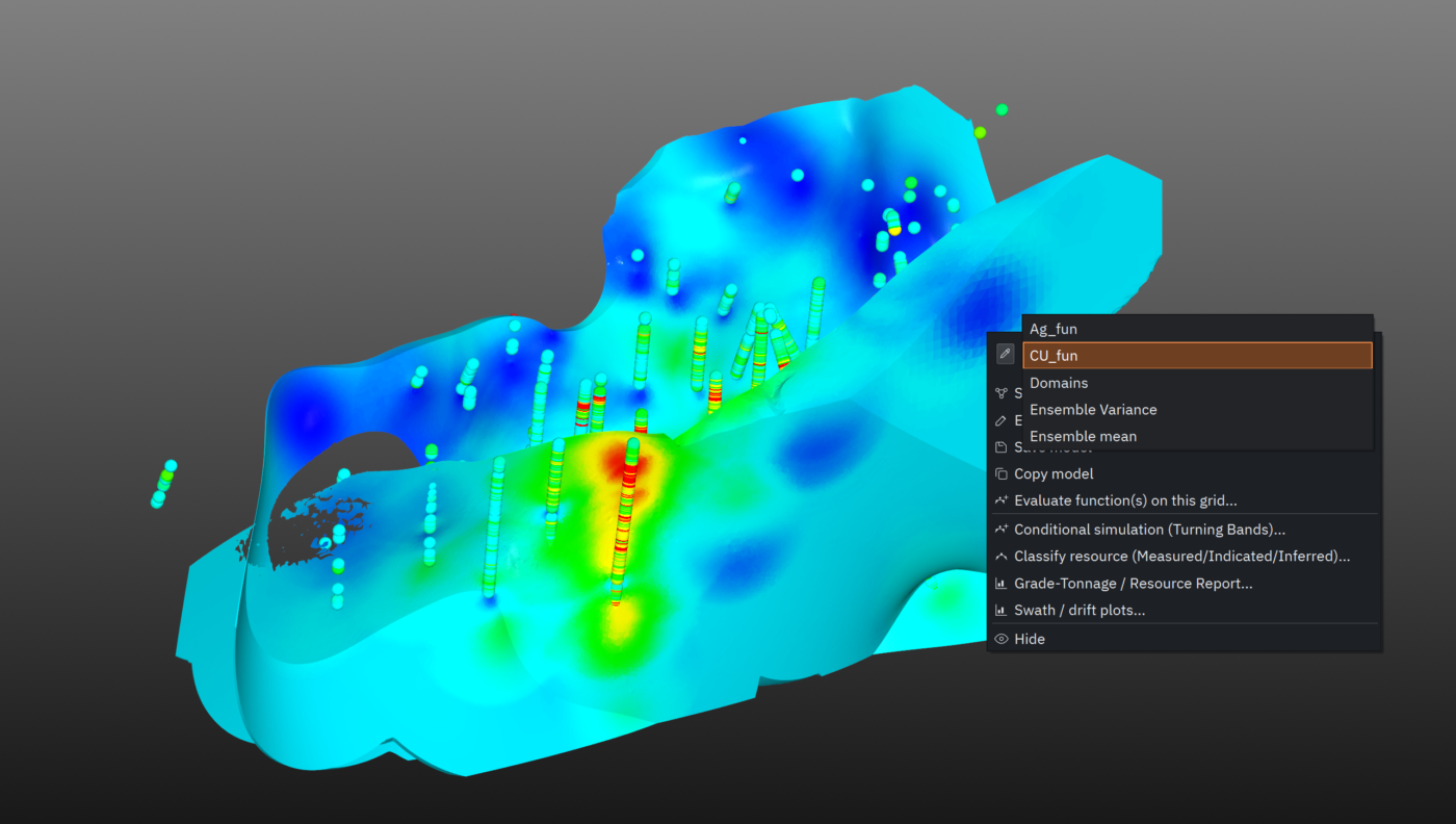
IDW, RBF and machine learning regression are built into GEOREKA’s modelling engine, with ordinary kriging and full variography in Premium. View two estimation results at once in the 3D window with real-time cut-off adjustment, and read tonnage, grade and volume for any cut-off straight from the information panel. Evaluate on regular grids or directly on the geological model for volume-weighted grade averages.
ORIENTATION-AWAREPremium
Estimation that follows the mineralisation
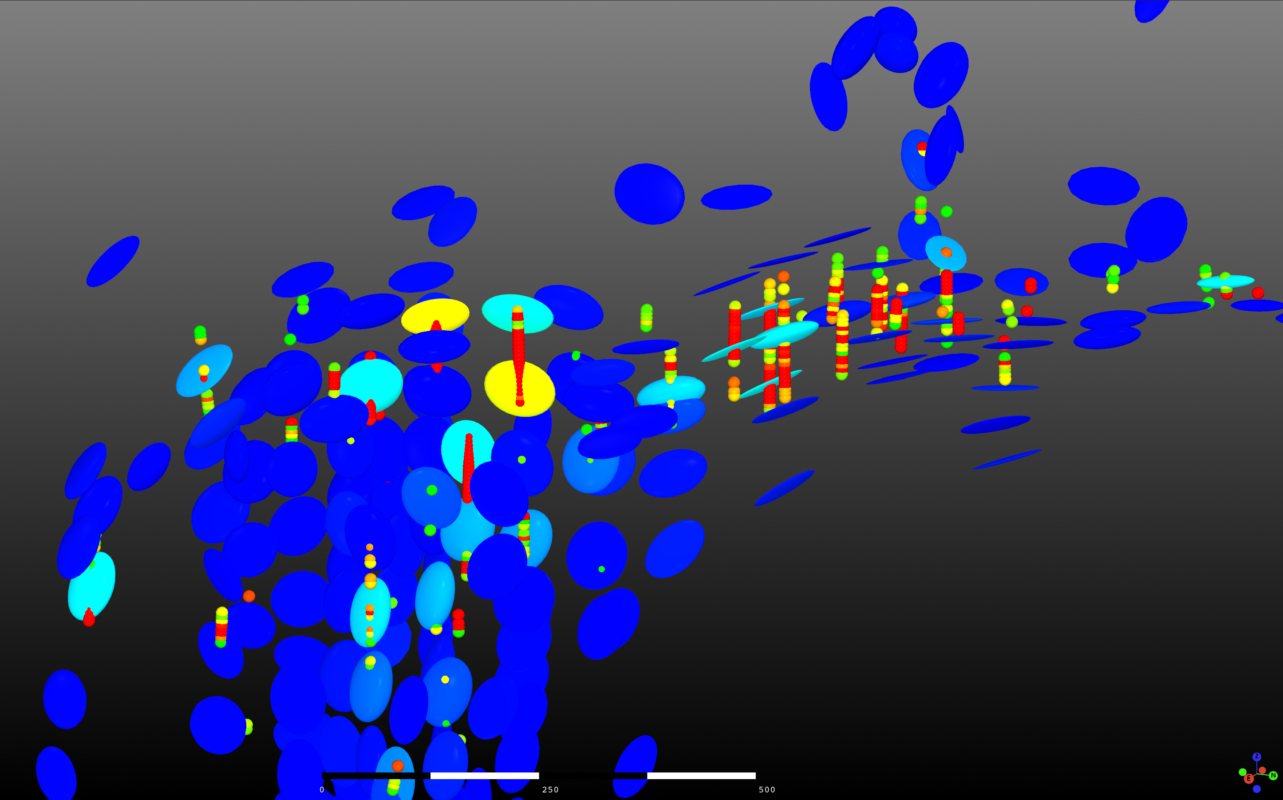
GEOREKA derives locally varying anisotropy (LVA) directly from your assay data. The LVA field is not just displayed: it drives the domains, the variograms and the numbers you report. Your estimate follows the true orientation of the mineralisation, not a single global ellipse, which matters most for folded, branching or structurally controlled deposits.
GEOSTATISTICSPremium
Variography and dual ordinary kriging
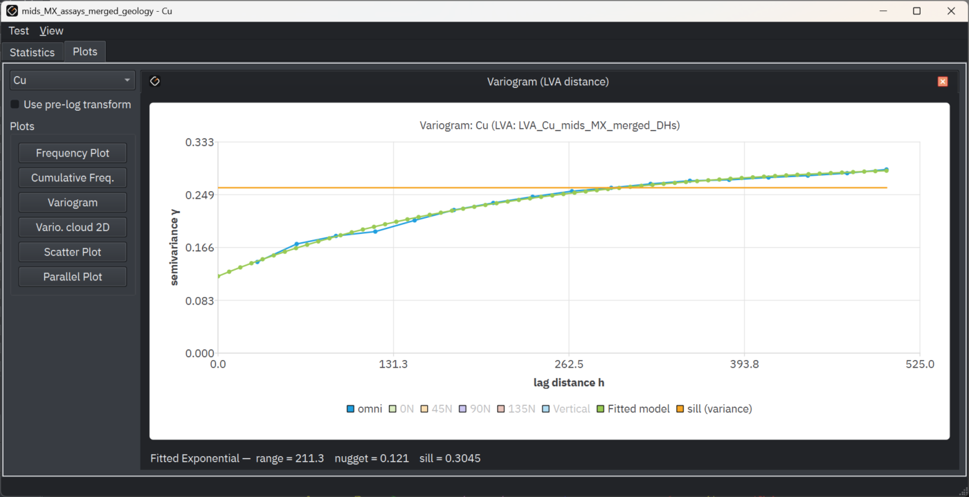
The full geostatistical toolkit runs on the same model and the same data, with parallel algorithms and GPU support for the heavy lifting. Dual ordinary kriging, like RBF and SVR, uses every data point in the estimate, so there is no search radius or neighbourhood to design.
- Exploratory data analysis
- Variography with anisotropy fitting
- Dual ordinary kriging using all data points
VALIDATIONPremium
Validate every estimate before you trust it
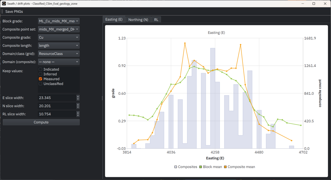
Check the estimate against the data it came from. Swath plots show whether the estimate follows the drillhole means along the deposit, cross-validation tests the estimation parameters, and side-by-side comparison shows how much the choice of method changes the answer.
- Swath plots by direction
- Cross-validation
- Side-by-side comparison of two methods in 3D
UNCERTAINTYPremium
See how much the answer could vary
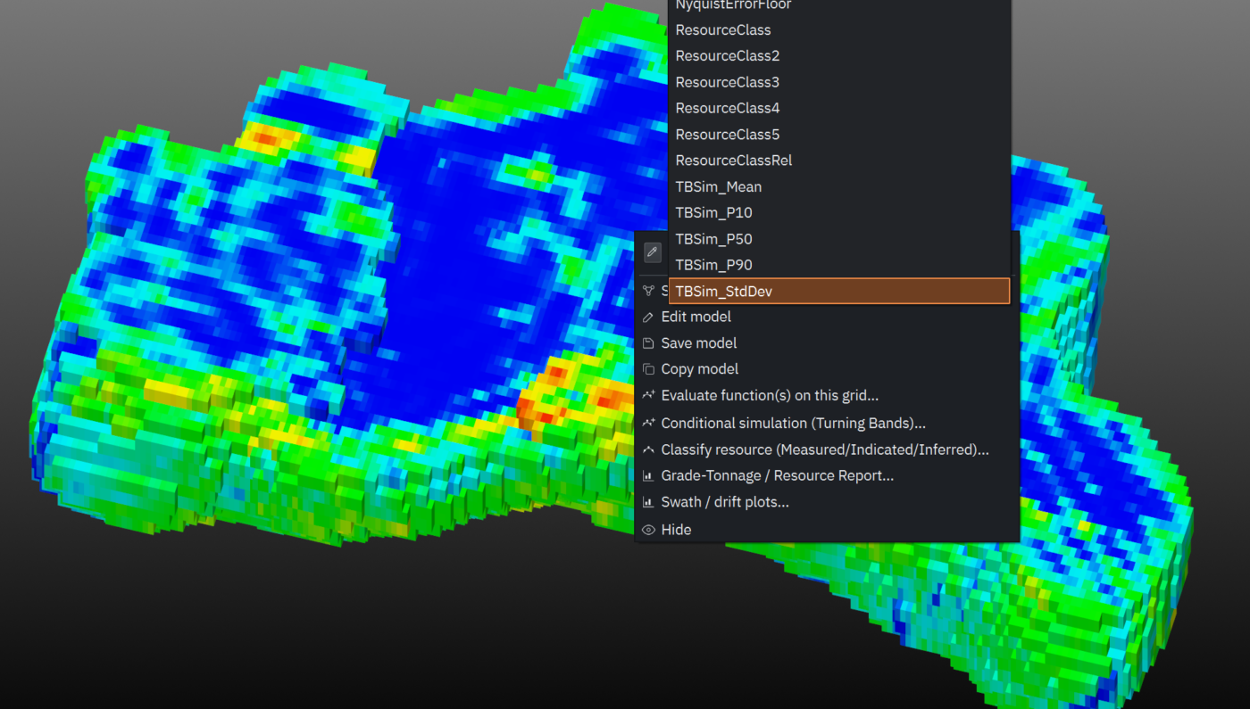
Conditional simulation produces many equally probable versions of the grade field that all honour your data. Instead of relying on a single smoothed estimate, you can see how much tonnage and grade could vary, and where the model is least certain.
GRADE-TONNAGEPremium
From estimate to resource statement
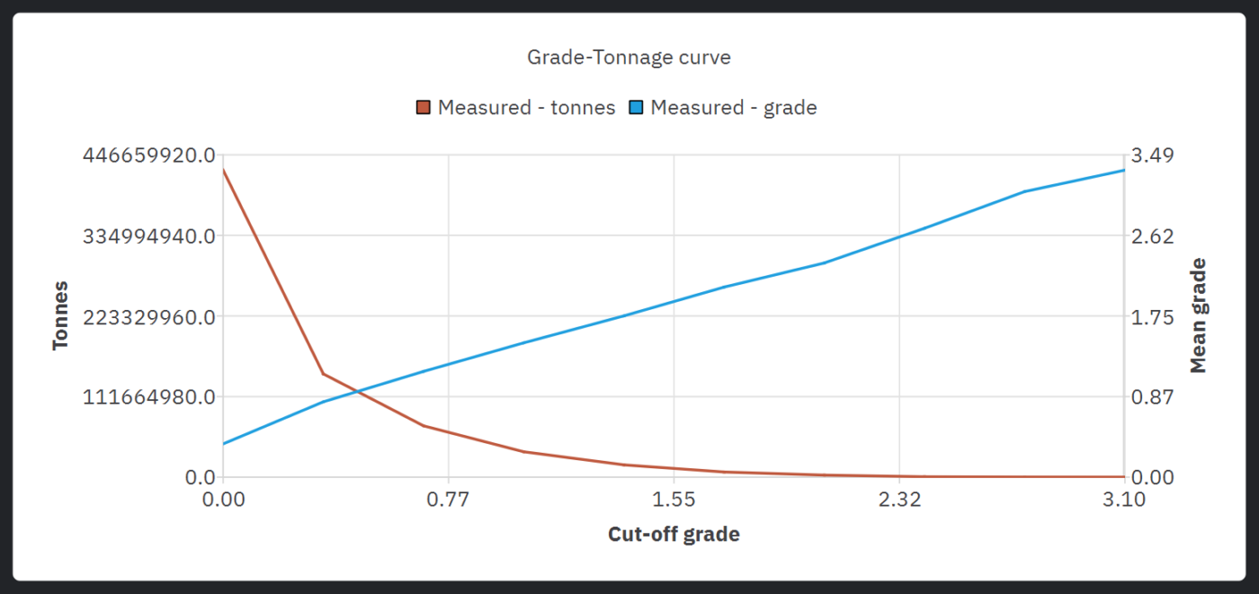
Report tonnage and grade by domain and cut-off, with Measured, Indicated and Inferred classification support, in the same application and on the same model. No export, no second package and no extra module.
Defensible by design
Why the numbers hold up
Traceable
Every result traces back to its input data through a visible, node-based workflow. There are no hidden parameters between the raw drillholes and the final model.
Comparable
Run different methods on the same data and see them side by side, so you can show a reviewer why you chose the method you did.
Reproducible
The workflow documents your method and can be re-run on new data. One screenshot shows a reviewer the whole process from raw drillholes to final model.
Core and Premium
What each tier includes for estimation
| Capability | Core | Premium |
|---|---|---|
| IDW, RBF and machine learning regression | Included | Included |
| Ordinary (dual) kriging with full variography | —Not included | Included |
| Estimate on regular grids or directly on the geological model | Included | Included |
| Two estimates side by side in 3D with real-time cut-off adjustment | Included | Included |
| Tonnage, grade and volume at any cut-off from the information panel | Included | Included |
| Multi-element clustering and linked 2D/3D plots | Included | Included |
| LVA field derived from your assay data | Included | Included |
| LVA integrated with variography and estimation | —Not included | Included |
| Exploratory data analysis and declustering | —Not included | Included |
| Kriging Neighbourhood Analysis | —Not included | Included |
| Swath plots and cross-validation | —Not included | Included |
| Conditional simulation | —Not included | Included |
| Grade-tonnage reporting by domain and cut-off, with classification support | —Not included | Included |
| Drillhole QA/QC: standards, blanks and duplicates | —Not included | Included |
| Python console and MCP connection | —Not included | Included |
Core is a complete way to estimate, compare methods and read tonnage and grade, on the model you built. Premium adds what you need to defend an estimate to a reviewer: kriging, variography, validation, simulation and reporting.
Related
Continue through the workflow
Geological modelling
Implicit and explicit workflows, true 3D domains, structural modelling and fast model updates.
Block modelling
Block, solid or tetrahedral output, populated with grade and interrogated at any cut-off.
Classification & reporting
Classification support and grade-tonnage reporting, and what GEOREKA does and does not certify.
Questions
Frequently asked questions
What is mineral resource estimation?
Resource estimation uses drillhole sample data and a geological model to estimate the tonnes and grade of mineralisation in the ground, and to report them with a level of confidence. GEOREKA estimates directly on the 3D geological model, so grades are volume-weighted within the domains you defined.
Which estimation methods does GEOREKA support?
Core includes inverse distance weighting (IDW), radial basis function (RBF) interpolation and machine learning regression. Premium adds ordinary (dual) kriging with full variography, and conditional simulation.
What is the difference between Core and Premium for estimation?
Core gives you basic estimation and method comparison, with tonnage, grade and volume at any cut-off. Premium adds kriging, variography, exploratory data analysis, declustering, Kriging Neighbourhood Analysis, swath plots, cross-validation, conditional simulation, classification support and grade-tonnage reporting.
How do I check that an estimate is reliable?
Compare methods side by side in 3D (Core), then use swath plots and cross-validation (Premium) to test the estimate against your drillhole data. The node-based workflow keeps every step visible for review.
Does GEOREKA produce JORC or NI 43-101 reports?
GEOREKA supports the technical work behind a report: validated estimates, classification support and grade-tonnage tables. The Competent or Qualified Person remains responsible for classification and sign-off. Read what GEOREKA does and does not certify.
Get started
Run a full estimation on your own data.
The 14-day trial includes every Premium feature, so you can take a model from drillholes to grade-tonnage results before choosing a tier.